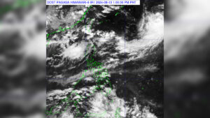
The tropical storm that exited the Philippine Area of Responsibility (PAR) on Monday, now with international name called “Ampil,” is expected to intensify the Southwest Monsoon (Habagat), causing rainfall in western section of Luzon and Visayas region, according to the state weather bureau.
“So malayo siya eh outside of PAR, kaya lang ‘pag may ganito tayong system ang nangyayari nahahatak yung Soutwest Monsoon, so itong Western section maulan, [It is far from the PAR, but when we have a system like this, it pulls the Southwest Monsoon that will cause rain fall in the Western section],” Rosalie Pagulayan, weather specialist of the Philippine Atmospheric Geophysical and Astronomical Services Administration (PAGASA) said in an interview.
In a weather forecast by PAGASA, areas in Luzon, primarily the western section including the Ilocos Region, Zambales, Batanes, and Babuyan Islands are expected to experience cloudy skies with scattered rain and thunderstorms.
Meanwhile, Metro Manila, the rest of Luzon, Western Visayas, and the Negros Island Region are expected to have partly cloudy to cloudy skies with isolated rain showers or thunderstorms.
According to a report from PAGASA on Tuesday, the tropical storm is situated 1,570 km East-Northeast of extreme Northern Luzon (23.5°N, 136.8°E) and is expected to move further towards Japan.
“Mukang hindi na (papasok sa PAR) kasi ang kanyang movement ay northeast eh, so kung nandon na siya outside PAR tapos northeast pa siya so parang away siya from the country [It seems like it will not enter the PAR anymore because its movement is toward the northeast. So, if it’s already outside the PAR and moving toward northeast, it is moving away from the country],” Ms. Pagulayan said.
Ms. Pagulayan urges the public not to be complacent, as rain showers and thunderstorms will continue to affect the country until the Southwest Monsoon ends in October and transitions to the Northeast Monsoon (Amihan). – Edg Adrian A. Eva


