Tropical Depression Paolo forms, may hit Luzon by Friday — state weather bureau – BusinessWorld Online
By Edg Adrian A. Eva, Reporter
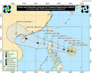
TROPICAL Depression Paolo has developed from a low-pressure area east of Catanduanes in the Bicol region and was expected to make landfall over Isabela or northern Aurora on Friday, the state weather bureau said on Wednesday.
As of 2 p.m., Paolo was spotted 695 kilometers east of southeastern Luzon with maximum sustained winds of 55 kilometers per hour (kph) near the center and gusts of up to 70 kph, the Philippine Atmospheric, Geophysical and Astronomical Services Administration (PAGASA) said. It was moving westward at 25 kph.
PAGASA weather specialist John A. Manalo said the country’s 16th cyclone this year was projected to strengthen into a severe tropical storm as it nears the country and could further intensify into a typhoon.
“As it approaches our country, our analysis shows that it will continue to strengthen and intensify into a severe tropical storm,” he told a news briefing.
There was a possibility of raising Tropical Cyclone Wind Signal No. 1 over the eastern portions of Northern and Central Luzon by Wednesday afternoon or evening, which could escalate to Signal No. 3 or even No. 4 as Paolo crosses land, he added.
While the cyclone was unlikely to directly affect the country within 24 hours, rains were expected in Northern and parts of Central Luzon starting Friday morning. Authorities also warned of possible flooding and landslides in areas along the storm’s path.
PAGASA issued Storm Surge Warning No. 1 over Aurora, Cagayan and Isabela, warning of a minimal to moderate risk of storm surges between one and two meters over the next 48 hours.
Residents in coastal areas were advised to stay away from beaches and suspend sea activities. Local governments were urged to prepare evacuation centers and pre-position relief goods as the storm approaches.